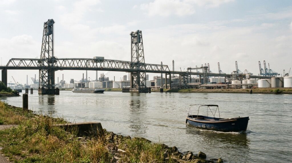
The sailing route from De Boompjes to the Botlek in Rotterdam is a trip over busy water; the route shown has 36 bridges. The distance and sailing time depend on the chosen route, your sailing speed and the traffic situation on the water.
A straight line on the map doesn't tell the whole story. Bridges, busy shipping traffic and the characteristics of your boat also determine how much time you need. So it makes sense that you want to know in advance whether the trip fits into your planning.
In this practical guide you can read which route choices are available and how distance and sailing time relate to each other. You will also discover why the situation on the Nieuwe Maas and bridge passages is important. This way you can better adjust the tour to your plans and know what to expect along the way.
Key points
- Map the bridge passages and the characteristics of your boat before departure; available Height, Width and draft also determine which route is suitable.
- Take into account the difference between the New Meuse and the old Meuse: the listed minimum depth is 13.7 M and 5 m, respectively.
- When planning, take into account the clearance of bridges along the route. The traffic situation on the busy waterway also plays a role in your planning.
- The route to Rotterdam runs via the Delftse Vliet, the Rijn-Schie Canal and the Delftse Schie to the Nieuwe Maas; locks may require additional sailing time.
- Are you looking for a well-groomed cruise for a festive occasion in Amsterdam? Then take a look at the possibilities for a private cruise, a BBQ boat Arrangement or a drink boat Arrangement.
Choosing a viable sailing route
A feasible route fits the dimensions and draft of your boat. Bridges, locks and crowds on the Rotterdam waterways also play a role in your planning.
Route from De Boompjes to the Botlek
The route from De Boompjes to the Botlek runs from Rotterdam over the Nieuwe Maas towards the Botlek area. So don't just choose your route based on the shortest line on the map. The waterways and passages along the way must also be suitable for your vessel.
Bridges and locks can affect the total sailing time. As a result, a further sailing area is not practically feasible for every rental period. For a short cruise it is advisable to stay closer to Delfshaven and De Schie. The Nieuwe Maas requires extra attention: the described route is suitable for larger ships, but not for beginners; those who want to thoroughly prepare for sailing on busy waters can go to the steerage license for a theory and practical training Vaarschool.be.
Depth and clearance restrictions
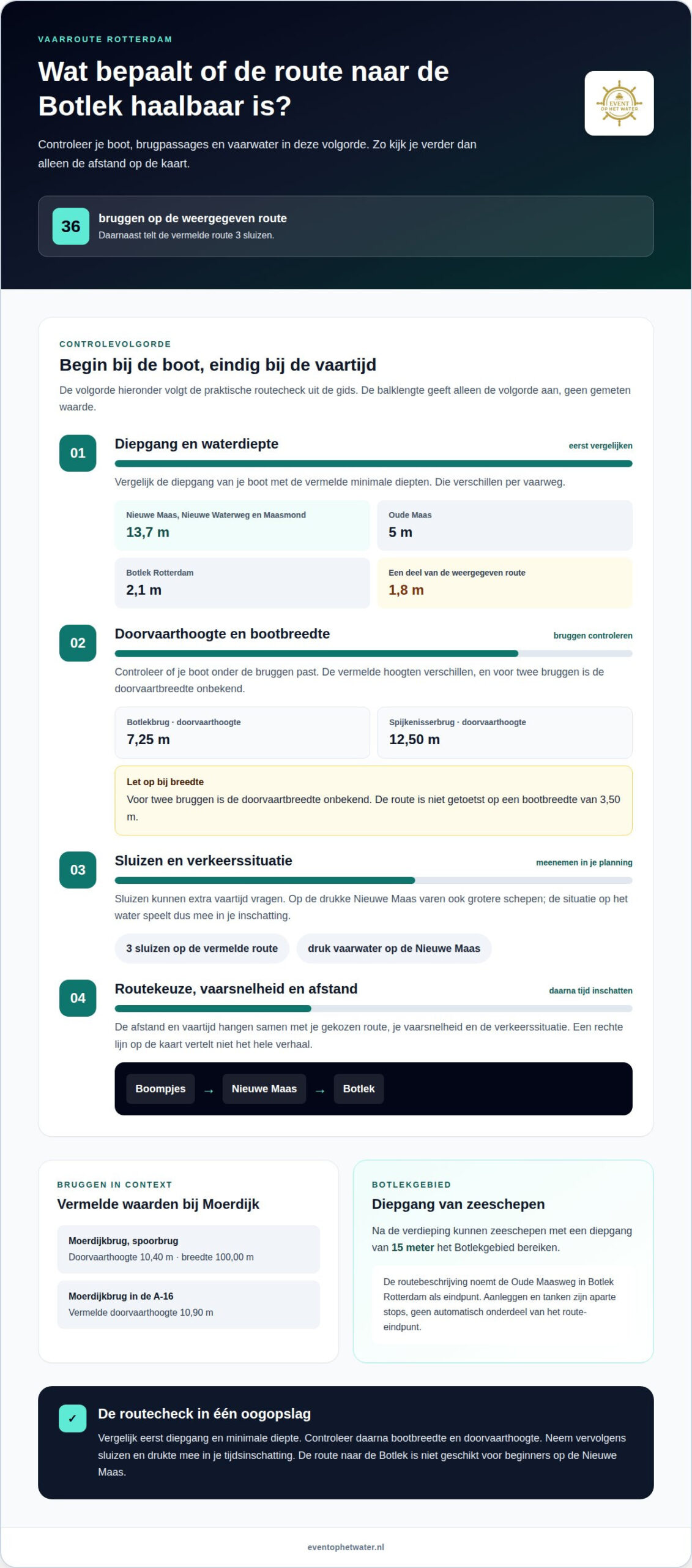
Passage height is the space available under a bridge; depth is the water column under your boat. On the route, these values differ per waterway and bridge. At Botlek Rotterdam the minimum depth is 2.1 m.on the Nieuwe Maas, Nieuwe Waterweg and Maasmond it is 13.7 m; on the Oude Maas it is 5 m.
For Bridges, both height and width play a role. The Botlek Bridge has a listed crossing height of 7.25 m, compared to 12.50 m at the Spijkenisser Bridge. For two bridges, the passage width is unknown; the route has not been tested for a boat width of 3.50 m. Keep this in mind when choosing your vessel.
Other values also provide context. The Moerdijk Bridge, spoorbrug, has a passage height of 10.40 m and a passage width of 100.00 m. the Moerdijk Bridge in the A-16 has a listed passage height of 10.90 m. after the deepening, sea vessels with a draft of 15 meters can reach the Botlek area. A part of a displayed sailing route has a minimum depth of 1.8 m.
Bridges, locks and obstacles
Bridges, locks and commercial navigation are obstacles that affect the route and sailing time. The displayed route has 36 bridges. The listed route also has 3 locks. These passages require planning that takes account of the route and the operation of locks.
The Nieuwe Maas is an important focus on this route. The water is used by larger ships and therefore requires extra attention. Combine the bridge passages with the dimensions of your boat: for example, the height under the Botlek Bridge differs from that at the Spijkenisser Bridge. The width restriction at two bridges is unknown, so the route has not been tested for a boat width of 3.50 m.
Make your route choice step by step: first, compare the draft of your boat with the listed minimum depths. After that, check whether the boat width and passage height match the bridge passages. Also include the locks and traffic situation on the Nieuwe Maas in your time estimate. This way you avoid that only the map distance determines whether the trip seems feasible.
Start and end point
Docking and refueling are separate stops, not automatically the point of departure or end. For this route, the Oude Maasweg in Botlek Rotterdam is the mentioned terminus. Therefore, include a docking or refueling stop separately in your planning.
Starting point at De Boompjes
De Boompjes is the starting area on the Rotterdam waterfront. Use this recognizable point as the beginning of your route planning, but also record where exactly you will board. An area designation is not the same as a landing site. Therefore, write down a concrete departure location on the trees.
Then Plan back from your desired departure time. Write down where your company is gathering and how much time it takes to board. This way you prevent the sailing time from starting while participants are still on the way. This preparation is extra useful for a trip to Botlek, because after departure you sail on Rotterdam's waterway.
Keep departure, docking and refueling as separate parts in your schedule. A docking stop is intended to temporarily go ashore; for refueling, you need a location where fuel is available. So do not assume that such facilities are present at the trees. Put a possible stop separately on your route map and calculate time for it.
Terminus in Botlek Rotterdam
The Oude Maasweg in Botlek Rotterdam is the mentioned end point of the described route. Use that name as a geographic anchor when planning your arrival. The indication of the end point in itself does not say anything about docking options or fuel. Therefore, keep the arrival location separate from any amenities you may need along the way.
Make the same practical layout before arrival as before departure. First note the end point, then any intermediate stops and finally the place where you end the tour. This way it remains clear whether the Oude Maasweg is only the route Terminus or also connects to your further plans. Don't confuse this with a fuel stop.
When making a round trip, it is useful to clearly distinguish the departure and end points from each other. The route description mentions the Oude Maasweg as the start and end point. The title of this guide also mentions the trees and the Botlek. Use the exact route variant you are sailing so that departure, turning point and Arrival do not mix up.
Pre-insert Stops
Start your practical planning with three separate points: departure at De Boompjes, a possible stop and arrival in Botlek Rotterdam. Add refueling only as a separately planned part. This prevents you from confusing a desired stop with a facility at the route endpoint. Also write down the goal per point, such as collecting, briefly docking or shutting down.
Then compare the order of those points with your sailing plan. A stop before the bone leak changes the time you spend on the water. A stop after arrival is part of your further plans on land. By writing down both scenarios separately, you keep an overview of the trip from the trees to the Oude Maasweg.
Finally, make a simple overview with the names Boompjes and Oude Maasweg, plus any planned stop locations. This way everyone can keep the same departure and arrival points. Write down the route and practical arrangements together, so that it remains clear where the cruise starts and where you expect to arrive.
Sailing distance and time
Sailing distance is the length of a route over navigable waterways. Sailing time is the time it takes to cover that distance. For the sailing route rotterdam from De Boompjes to the Botlek, the estimate depends on the chosen route, your speed and the traffic situation on the water. Thus, only the distance on the map does not give a complete planning.
A displayed route has a total distance of 116 kilometers and an estimated sailing time of 14 hours and 30 minutes. Other routes shown are 89 kilometers with an estimated duration of 11 hours and 8 minutes, and 81 kilometers with 10 hours and 8 minutes. These are route examples, not sailing durations for the Route Boompjes-Botlek. Differences in distance and route choice lead to different travel times.
A separate example is Botlek Rotterdam to Drimmelen: that route is 50 km long. The estimated sailing time is 6H 15m, calculated at a speed of 8 km/h. use this example as a comparison only. The route to Drimmelen is not the same as the trip from De Boompjes. The distance and duration can therefore not be taken over one on one.
When planning, also take into account how much time you actually spend sailing. Bridges and locks affect the total sailing time in Rotterdam. A passage or waiting time can cause you to arrive later than a simple calculation based on distance and speed suggests. Take these route parts with you when you put departure and arrival time side by side.
The traffic situation on the Nieuwe Maas is also important. You share the sailing water with larger ships and the described route is not suitable for beginners. This requires attention to the environment and a realistic assessment of your pace. A calculation with only a constant speed does not take into account passages, crowds or changes along the way.
Work out your planning in three steps. First, decide which waterways you want to follow. Then calculate the expected sailing time based on the route length and your sailing speed. Finally, allow extra time for bridges, locks and traffic. This way you can see why a longer route does not automatically take proportionately more time: the conditions on the way also determine the pace.
Also distinguish between a single trip and a round trip planning. The return voyage adds a second leg, while a stopover further extends the total time. Write down the desired departure time, possible stops and arrival separately in your schedule. This way you avoid confusing sailing time with the total duration of your outing.
So use route numbers as context, not as a fixed promise for every trip. The examples of 116 kilometers, 89 kilometers and 81 kilometers show how diverse routes can be. For De Boompjes and De Botlek, a useful time estimate mainly revolves around the chosen route, speed, bridges, locks and traffic situation on the Nieuwe Maas.
For a successful trip, good preparation is essential. When planning for several days, also take into account individual stages. The second stage to Vlietland takes 3 hours sailing. The stage to Delft or The Hague takes 3 to 4 hours sailing. Add those times to any previous sailing and plan enough space for stops and unforeseen delays.
What is the sailing route from De Boompjes in Rotterdam to the Botlek?
The route from the Boompjes to the Botlek follows Rotterdam's water towards the port area. The displayed route has 36 bridges. The exact line on the map depends on the chosen route variant. Therefore, read the route as a series of fairway sections, not as one straight connection.
Depart from the Boompjes and follow the indicated waterway towards the Nieuwe Maas. Use the map as a guide and pay attention to where the waterway bends towards Botlek Rotterdam. This way you avoid navigating only by place names. Botlek is an area, while the route map shows a concrete sailing line.
The depth indication differs per part of the displayed route. On some sections, 5 meters is listed as the minimum depth; on others, it is 3 meters. These values do not automatically apply to the entire process. When planning, read which part of the fairway belongs to which depth. This prevents one number from being seen as a characteristic of the entire route.
The number of Bridges also requires accurate reading. The displayed sailing route has 36 bridges, but that number describes the route display. It does not say by itself how long each passage takes or which bridges you will encounter on an alternative route. Therefore, compare the line on the map with the fairway you actually want to follow.
When viewing the map, use this sequence:
- Start: determine the exact place of departure near the saplings.
- Path: follow the sailing line towards Botlek Rotterdam and recognize the mentioned waterways.
- Passages: highlight the bridges that are on the route view.
- Depth: note where 5 meters and where 3 meters are listed.
- Destination: determine which point in the Botlek you use as the endpoint.
These steps make visible where the roadmap gives concrete data. The listed depths of 5 meters and 3 meters belong to parts of the displayed route. Do not use them as a general value for all waterways between Rotterdam and the Botlek. The same applies to the 36 bridges: a different route variant can show a different line and other passages.
Good directions therefore require both map reading and the recognition of place names. Follow the drawn fairway from the trees, check the indicated depth per section and keep the bridges on your route in view. This way you can assess the connection to Botlek Rotterdam concretely, without confusing route distance, depth and the number of bridges.
When giving directions, also pay attention to the difference between an intermediate point and the destination. The Nieuwe Maas is a waterway; Botlek Rotterdam designates the port area. Before the sailing line reaches the chosen end point, the map can show several sections of the fairway. Therefore, write down the names in order, from the trees to the specific point in the Botlek.
The map thus shows three usable connection points: 36 bridges on the displayed sailing route, a minimum depth of 5 meters on parts and 3 meters on other parts. Combine that data with the drawn route. This creates a clearer picture of the connection between the trees and the Botlek than a single distance measurement can give.
Which waterways, ports and locks are on this route?
A fairway is the navigable water between two waypoints. The Nieuwe Maas is an important landmark on the route towards Botlek. Then the route continues towards the Botlek area in the Port of Rotterdam. Which parts of the waterway you follow depends on the chosen approach route to Rotterdam.
If you come from Delft or The Hague, the route to Rotterdam runs over the Delftse Vliet, the Rijn-Schie canal and the Delftse Schie. These waterways open onto the Nieuwe Maas, after which you continue sailing towards Botlek Rotterdam. See this as a possible approach to Rotterdam, not as a fixed route from De Boompjes.
A lock is a passage that moves ships between watersheds with different water levels. The displayed sailing route has 3 locks. That number belongs to the route display and does not automatically make it clear where each lock is located. The route from Delft or The Hague uses different waterways before reaching the Nieuwe Maas. Therefore, keep lock passages separate in your sailing schedule.
A port area is a zone of waterways and port destinations. Botlek Rotterdam is part of the Port of Rotterdam. The Nieuwe Maas connects the city with the port area. The Delftse Vliet, the Rijn-Schie Canal and the Delftse Schie are especially relevant if your approach route is from Delft or The Hague. From De Boompjes it is about the continuation via the Nieuwe Maas towards Botlek.
When reading a roadmap, use this order:
- Run up: recognize whether your route runs via Delftse Vliet and Rijn-Schiekanaal.
- Fairway: follow the Delftse Schie towards the Nieuwe Maas.
- Transition: note that the displayed route counts 3 locks.
- Port: follow the connection from the Nieuwe Maas towards Botlek Rotterdam.
This way you avoid confusing different route variants. A route from Delft or The Hague involves a longer approach than a trip that starts at the trees. The listed 3 locks belong to the displayed route; do not treat them as the number of locks on each possible route to the Botlek.
Also pay attention to the difference between a waterway and a destination. The Delftse Schie is a waterway name; Botlek Rotterdam is an area in the harbour. The Nieuwe Maas connects the urban route with the port area. That distinction helps you follow the roadmap and put the places in the right order.
A route description becomes clearer if you write down waterways, locks and destinations separately. Put the names in the order in which you encounter them and keep the chosen approach route recognizable. This way you follow the route from De Boompjes to Botlek Rotterdam accurately.
Another route variant is that from Botlek Rotterdam to Drimmelen: it includes 0 locks. On that route, the passage width of 2 of the 5 Bridges is unknown. The stated Draught is 1.20 m. check this information before you leave, so that you know which restrictions are relevant for your vessel.
Destinations in the area may also request additional lock passages. The Rotte is accessible via locks and therefore requires extra attention for sailing time and lock operation. For the Kralingse Plas and Bergse Plassen you also have to sail via locks; the feasibility depends, among other things, on the available sailing time and the operation of the locks. The route from Delft or The Hague to Rotterdam takes about 4 to 5 hours.
Event on the Water: Private Cruise
Event op het Water organizes exclusive private cruises in the Rotterdam region for a relaxing getaway on the water. The route from De Boompjes to the Botlek helps you think about distance and sailing conditions; if you are also looking for a festive cruise in the port region, a private tour fits perfectly with that plan.
For example, choose a Borrelboot package for a cozy get-together or a BBQ boat package for a joint meal on board. The tours include a skipper, so you and your party can enjoy the Rotterdam waterways and the impressive Harbor without any worries.
Want to celebrate a special occasion on the water? Contact Event op het Water and discuss your wishes for an unforgettable private cruise.
Make your next cruise an experience
The sailing route from De Boompjes to the Botlek can help you determine what you are looking for: practical route planning or a relaxing getaway. Do you want to enjoy a special cruise with your company? Then choose an occasion and atmosphere that suits your plans.
Event op het Water organises private boat trips for groups. For example, choose a drink boat or BBQ boat for a festive get-together. In this way, the cruise itself becomes part of the meeting, instead of just the journey to a destination.
Do you have an opportunity in mind? Contact Event op het Water to discuss your wishes for a private cruise. This is how you take the first step towards a getaway on the water.
Disclaimer
Some images on this website are (partially) generated or edited using artificial intelligence (AI). These images serve solely for illustration and Atmospheric impression. The actual boats, locations, arrangements, facilities and performances may differ from what is shown in the image. No rights can be derived from AI-generated images.
To contact us via [email protected] for more info.